83.
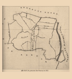
MAP OF SINT PANCRAS
MAP OF SINT PANCRAS
Sint Pancras is an old village in the North of Holland. The map shows the lotting out of the wetland around the village to make it suitable for agriculture. This pattern is created by men and nature working together. Although there is no agriculture around the village anymore, some of the lotting out patterns can still be found in the contemporary landscape of the village.
See GLOSSARY:
ASSEMBLAGE, BORDER, COMMEMORATION, CONTOUR, CRUST, DATA, DIAGRAM, FIGURE, HOUSE, LETTING-OUT, LIFE-SIZE, OUTLINE, OUTSIDE, TOPOGRAPHIC POINT, TRANSGRESS, VEGETAL
See WORK:
XIII
ASSEMBLAGE, BORDER, COMMEMORATION, CONTOUR, CRUST, DATA, DIAGRAM, FIGURE, HOUSE, LETTING-OUT, LIFE-SIZE, OUTLINE, OUTSIDE, TOPOGRAPHIC POINT, TRANSGRESS, VEGETAL
See WORK:
XIII
